
Choosing the right drone mapping camera system is about more than camera resolution. For mapping, inspection, and survey-style work, you need consistent image quality, stable flight, accurate positioning, and a workflow that saves time in the field.
Below, we’ve rounded up 10 strong options for 2026, from enterprise-focused platforms to lighter, budget-friendly drones that can still support mapping-oriented aerial capture.
Best 10 Drone Mapping Camera Systems Picks for 2026
Enterprise Thermal Mapping
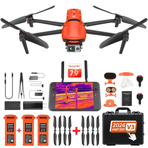
- 640×512 thermal imaging with temp measurement modes
- 50MP visible camera with RYYB CMOS sensor
- 15km transmission and 42-minute flight time
Best For: Enterprise mapping, inspection, and public safety missions
Cinematic Triple-Camera

- Triple-camera system with 100MP Hasselblad main camera
- 6K HDR video with 360 Infinity Gimbal
- 51-minute flight time and 512GB creator bundle
Best For: Creators and commercial teams needing flexible aerial imaging
Portable Enterprise Imaging

- 1-inch CMOS 6K camera with adjustable aperture
- Three batteries for up to 120 minutes total flight time
- Compact 352g build with 12km transmission
Best For: Portable inspection and enterprise imaging work
Premium 6K Mapping-Ready Flagship

- 1-inch Sony sensor with 6K HDR video
- 12-bit DNG support for deeper post-production
- 15KM transmission with 40-minute flight time
Best For: High-end aerial imaging and mapping-focused pilots
Long-Endurance GPS Pick

- 4K camera with 3-axis gimbal stabilization
- 75 minutes total flight time with 3 batteries
- Waypoint, orbit, follow, and auto return modes
Best For: Long flights with simple GPS-assisted control
Rugged High-Detail Bundle
Autel EVO 2 Pro V3 Rugged Bundle

- 1-inch Sony sensor with 6K HDR recording
- 15 km SkyLink 2.0 transmission
- Smart Controller SE with 6.4-inch OLED screen
Best For: Premium imaging users who want a complete controller bundle
Compact GPS Starter
Potensic ATOM SE 4K Foldable Drone

- Under 249g foldable body
- 4K EIS camera with 12MP stills
- Up to 62 minutes total flight time
Best For: Beginners who want an easy GPS drone for simple aerial capture
Pro Imaging Flagship
DJI Mavic 4 Pro Triple Camera Creator Combo

- 100MP Hasselblad main camera
- 6K HDR video with triple-camera system
- 512GB onboard storage and 51-minute flight
Best For: Advanced creators needing a premium aerial imaging platform
Screened Survey Drone

- 5.5" 1080P screen on the controller
- 3-axis gimbal with 4K video and 48MP stills
- Up to 64 minutes of flight time
Best For: Survey-style flying and beginners who want a controller screen
Enterprise Thermal Mapping – Autel EVO II Dual 640T V3
If you need drone mapping camera systems for inspection, search and rescue, or public safety work, the Autel EVO II Dual 640T Enterprise V3 brings a rare mix of thermal and visible imaging. Its 640×512 thermal sensor, 50MP visible camera, and 15km transmission make it a strong fit when you need to document sites, spot heat signatures, and keep a reliable live view from farther out.
Best For: Enterprise teams that need thermal imaging plus high-detail visual capture for mapping and inspection missions.
Pros:
- 640×512 thermal sensor at 30 fps with multiple temperature measurement modes
- 0.8-inch RYYB CMOS visible camera with 50MP detail and Moonlight Algorithm 2.0
- Up to 15km transmission with tri-band communication and anti-interference support
- 42-minute flight time and enterprise accessories support for broader mission use
Cons:
- RTK is not included in this bundle
- Enterprise-focused setup may be more than casual users need
- Thermal and advanced mission features add complexity versus simpler drones
This is a specialized mapping and inspection platform rather than a general hobby drone. If your workflow depends on thermal awareness, long-range control, and high-detail imaging in the field, it offers the tools to support professional operations.
Cinematic Triple-Camera – DJI Mavic 4 Pro Creator Combo
For drone mapping camera systems that also need strong creative video capability, the DJI Mavic 4 Pro Creator Combo stands out with its triple-camera setup and 6K HDR recording. The 100MP Hasselblad main camera, dual tele cameras, and 360 Infinity Gimbal give you flexible framing for large properties, landscapes, survey visuals, and client-ready aerial footage.
Best For: Creators and field teams who want one drone for mapping-style coverage, cinematic capture, and commercial video.
Pros:
- Triple camera system with a 100MP Hasselblad main camera
- 6K 60fps HDR video and 360 Infinity Gimbal for versatile compositions
- Up to 51 minutes of flight time for longer sessions
- 512GB Creator Combo includes RC Pro 2, batteries, charging hub, and accessories
Cons:
- Large 14-inch wide footprint and 13.8-pound package weight
- Bundle is geared toward advanced users and creators
- Primarily optimized for imaging and video rather than thermal or enterprise sensing
This bundle is best when image quality and workflow convenience matter as much as flight performance. If your projects demand polished aerial visuals, long sessions, and flexible framing, it offers a very complete creator-focused package.
Portable Enterprise Imaging – Autel EVO Lite 6K Plus
The Autel EVO Lite 6K Enterprise Plus Combo is a practical choice for drone mapping camera systems when portability matters. With a 1-inch CMOS 6K camera, adjustable aperture, and 16x digital zoom, it is built for detailed visual work in inspection, surveillance, and field missions without carrying a heavier enterprise platform.
Best For: Teams and solo operators who want a compact enterprise drone with strong visible-light imaging.
Pros:
- 1-inch CMOS 6K camera with F2.8-F11 aperture control
- 3 batteries provide up to 120 minutes total flight time
- 12km transmission and 3-way obstacle sensing for safer operations
- Lightweight 352g design makes it easier to pack and carry
Cons:
- Does not include thermal imaging
- Transmission range is shorter than some larger enterprise drones
- Primarily a visible-light tool, not a specialized mapping payload bundle
If you need an enterprise-capable drone that travels well and still delivers serious camera performance, this model fits the brief. It is especially appealing for users who prioritize compact size, long total flight time, and straightforward professional imaging.
Beginner Smart Camera – Ruko U11MINI 4K RC3
For buyers looking at drone mapping camera systems on a simpler budget, the Ruko U11MINI 4K pairs a smart touchscreen controller with a stabilized camera and long transmission range. It is designed to be easy to fly, with under-249g weight, AI takeoff and landing, and positioning tools that help new pilots get reliable aerial footage without a steep learning curve.
Best For: Beginners and casual users who want a portable drone with a built-in screen and stable camera.
Pros:
- Integrated 5.5-inch touchscreen controller with no phone required
- 8K photos and 4K/30fps video with a 3-axis gimbal
- Up to 20,000ft transmission and 64 minutes total flight time
- Under 249g with GPS, barometric, TOF, and optical flow positioning
Cons:
- Wi-Fi-based control is less specialized than enterprise transmission systems
- Camera is aimed at general aerial use rather than advanced mapping payloads
- Best suited to beginners, so advanced workflow features are limited
This is a straightforward option for users who want dependable aerial capture without overcomplicating the setup. It brings a strong mix of portability, stabilization, and ease of use for everyday flying and simple survey-style visuals.
Premium 6K Mapping-Ready Flagship – Autel EVO 2 Pro V3
If you’re comparing drone mapping camera systems and also want a strong all-around aerial camera, the Autel EVO 2 Pro V3 stands out for its 1-inch Sony sensor, 6K HDR video, and 12-bit DNG capture. It is built for pilots who want detailed image quality, long-range control, and reliable obstacle sensing in a single platform.
Best For: Pilots who want a high-end camera drone with strong image capture, long flight time, and advanced safety features.
Pros:
- 1-inch Sony CMOS sensor with up to 6K video and adjustable F2.8-F11 aperture
- 12-bit DNG support for greater post-production flexibility
- 360° obstacle avoidance with 12 computer vision sensors and 2 sonar sensors
- Up to 40 minutes of flight time plus 15KM transmission
Cons:
- No geo-fencing, so the pilot must manage flight restrictions manually
- Advanced feature set may be more than casual beginners need
- Bundle-focused listing means included accessories should be checked carefully
This is a strong choice if your priority is image quality first and operational range second. For drone mapping camera systems, the combination of a 1-inch sensor, 12-bit files, and stable long-range flight makes it a capable premium option.
Long-Endurance GPS Pick – Bwine F7GB2 Pro
For buyers looking at drone mapping camera systems on a budget-friendly, flight-time-heavy model, the Bwine F7GB2 Pro offers a 4K camera, 3-axis gimbal, and GPS flight tools that make it practical for planned routes and repeatable shots. Its strengths are steady control, long endurance, and useful automated flight modes.
Best For: Pilots who want long battery life, GPS-assisted flight, and a stable 4K camera setup.
Pros:
- 4K UHD camera with a 3-axis gimbal for steadier footage
- 75 minutes of total flight time with 3 batteries
- GPS features include follow, waypoint, orbit fly, and auto return
- FAA Remote ID compliance is already completed
Cons:
- Camera spec is 4K rather than higher-end 6K capture
- Control range may be overkill for some users but is not a mapping-specific feature set
- Best results still depend on careful battery and weather management
This model makes sense if endurance and easy flight planning matter more than premium imaging specs. It is a practical fit for pilots who want dependable GPS automation and a stable camera platform without moving into flagship pricing.
Rugged High-Detail Bundle – Autel EVO 2 Pro V3 Rugged Bundle
If you want drone mapping camera systems with premium imaging and a bundled controller setup, this Autel EVO 2 Pro V3 package is built around the same 1-inch Sony sensor, 6K HDR video, and 12-bit image capture found in Autel’s higher-end line. The rugged bundle adds the Smart Controller SE and keeps the focus on range, detail, and controlled operation.
Best For: Buyers who want a rugged Autel bundle with strong imaging, long transmission range, and a premium controller.
Pros:
- 1-inch Sony CMOS sensor with up to 6K video and F/2.8-F/11 aperture
- 12-bit DNG photos and Moonlight Algorithm 2.0 for low-light flexibility
- 15 km SkyLink 2.0 transmission with tri-band communication
- Includes Smart Controller SE with 6.4-inch OLED screen
Cons:
- Premium bundle may be more than budget buyers need
- No geo-fencing is mentioned, so compliance remains pilot responsibility
- Controller-centered package may be unnecessary if you already own compatible gear
This bundle is a strong option when you want the same imaging core as the flagship Autel model but with a more complete control package. It is especially appealing for users who value long-range operation and post-processing flexibility in a rugged setup.
Compact GPS Starter – Potensic ATOM SE 4K Foldable Drone
If you’re comparing drone mapping camera systems for a beginner-friendly platform, the Potensic ATOM SE is a lightweight option focused on portability, GPS stability, and simple aerial capture. It pairs a 4K EIS camera with GPS-assisted flight, auto return, and multiple smart modes, making it more about easy, dependable shooting than heavy-duty survey work.
Best For: Beginners who want a compact GPS drone for casual mapping-style capture, travel footage, and simple waypoint or follow-me flights.
Pros:
- Under 249g and foldable, so it’s easy to pack and fly without much hassle.
- 4K EIS camera with a 12MP still mode and stable PixSync 2.0 transmission support.
- Two batteries provide up to 62 minutes of total flight time.
- GPS features include auto return, Follow Me, Waypoint Flight, and Circle Flight.
Cons:
- Its camera and stabilization are aimed at casual capture, not advanced mapping workflows.
- Max range and image system are modest compared with premium creator drones.
- Best results depend on inserting a micro SD card for camera-related firmware updates.
The ATOM SE makes sense if you want an accessible drone that’s easy to learn and carries enough flight stability for straightforward aerial documentation. It’s not the most advanced mapping tool here, but it offers a practical balance of GPS features, portability, and 4K capture.
Pro Imaging Flagship – DJI Mavic 4 Pro Triple Camera Creator Combo
For buyers evaluating drone mapping camera systems at the high end, the DJI Mavic 4 Pro stands out as a pro-grade imaging platform with a triple-camera setup, 100MP Hasselblad main camera, and 6K HDR video. Its flight and sensing systems are built for controlled, cinematic capture, while the onboard 512GB storage streamlines large file workflows after each mission.
Best For: Advanced creators who need top-tier aerial image quality, long flight time, and a powerful camera system for professional content work.
Pros:
- Triple-camera system led by a 100MP 4/3 CMOS Hasselblad main camera.
- 6K HDR video, 0.1-lux Nightscape support, and omnidirectional obstacle sensing with LiDAR.
- Up to 51 minutes of flight time and a 30km maximum transmission range.
- 512GB onboard storage reduces dependence on removable memory cards.
Cons:
- Designed for advanced users, so it may be more drone than a casual pilot needs.
- The Creator Combo bundle is large and feature-rich, which may be overkill for simple use cases.
- Premium capabilities come with a more complex setup and workflow.
This is the strongest pick in the group for users who prioritize image quality, tracking, and professional capture features. If your workflow depends on maximum detail and robust flight confidence, the Mavic 4 Pro is built for that job.
Screened Survey Drone – Bwine F7MINI 4K RC3 Drone
If you want drone mapping camera systems with a controller that makes field review easier, the Bwine F7MINI 4K(RC3) is built around an integrated 1080P screen and strong stabilization. It combines 4K video, 48MP stills, a 3-axis gimbal, GPS smart modes, and long transmission range in a compact under-249g frame.
Best For: Survey-style flying, travel footage, and beginners who want live on-controller viewing and stable aerial capture.
Pros:
- 5.5″ 1080P screen on the remote helps with quick viewing and field checks.
- 3-axis gimbal plus EIS supports smoother 4K/30fps video and 48MP photos.
- Up to 64 minutes of flight time with two batteries.
- GPS features include Active Track, Cruise Control, Orbit Flight, Waypoint Planning, and Precise Hover.
Cons:
- Indoor use relies on switching to optical flow mode.
- Transmission and range claims can vary in harsh conditions.
- It’s a compact consumer drone, so it’s better for simple capture than specialized mapping payloads.
The F7MINI is a practical option if you value an easy-to-read controller screen and stable flight aids more than advanced pro hardware. It offers a solid mix of portability, GPS automation, and image stabilization for everyday aerial work.
How We Picked These Drone Mapping Camera Systems
We focused on image sensors, stabilization, flight endurance, transmission range, storage, and features that matter for repeatable aerial capture. For Drone Mapping Camera Systems, consistency is often more important than headline resolution, so we favored models with strong gimbals, dependable GPS, and sensors suited to clean, usable imagery.
We also considered whether the drone is better suited to professional mapping, inspection, or general aerial documentation, since not every camera drone is built for surveying tasks.
Quick Comparison
In this roundup, enterprise models stand out for thermal imaging, larger sensors, and advanced control options, while creator-style drones offer high-resolution cameras and long flight times for detailed visual capture. Lightweight drones can be a practical entry point if you need portability and simpler operation.
Key Buying Factors for Drone Mapping Camera Systems
Camera Sensor and Image Quality
Look for a larger sensor, stable color performance, and enough dynamic range to preserve detail in shadows and bright surfaces. For mapping, sharper images with lower noise usually help more than extreme zoom or flashy video specs.
Stabilization and Control
A 3-axis gimbal is a major advantage because it keeps frames level and reduces motion blur. Reliable positioning, smooth hover behavior, and accurate waypoint-style flight support better capture consistency.
Flight Time and Battery Planning
Longer flight time means fewer interruptions and more efficient coverage per outing. If you expect to map larger areas, battery bundles and fast turnaround time matter nearly as much as range.
Transmission, Storage, and Workflow
Strong video transmission helps maintain control, but local storage is just as important for high-resolution capture. Built-in storage, generous memory card support, and a clear review workflow can save time on site.
Payload and Use Case
Some Drone Mapping Camera Systems are designed for thermal, inspection, or enterprise work, while others are better for general aerial photography and content creation. Match the drone to the job: survey utility, environmental documentation, construction progress, or visual mapping.
Who Should Buy Which Drone Mapping Camera Systems?
Buy an enterprise drone if you need advanced imaging, thermal capability, or a more professional field workflow. Choose a creator-grade drone if your priority is high-resolution visual capture with excellent battery life. Go with a compact drone if portability, lower cost, and easier travel use matter most.
For best results, think about your typical project size, required image quality, and how much post-processing you’re willing to do. The right drone mapping camera system is the one that fits your workflow, not just your budget.